Colorado Web Cams
Great Sand Dunes National Park, Colorado
The tallest sand dunes in North America are all found here at Great Sand Dunes National Park and Preserve. The park is located south of Crestone and northeast of Alamosa, Colorado. Elevations range from 7,515 feet (2,291 meters) in the valley west of the dunes, to 13,604 feet (4,146 meters) at the summit of Tijeras Peak in the northern part of the preserve. The tallest sand dune rises to a height of 750 feet (229 meters). The dunes cover an area of about 30 sq mi (78 km2). and are estimated to contain over 1.2 cubic miles (5 billion cubic meters) of sand. Medano Creek, on the east side of the dunes, is never stable, as fresh sand falls in the creek, creating surges of water which resemble waves. The surges occur at an average interval of about 20 seconds. In a high-water year, the surges can be as high as 20 inches (51 centimeters). The "surge flow" is strongest during the peak flow period from May to early June in most years. The backcountry Medano Pass Primitive Road winds through a canyon toward the Sangre de Cristo mountains. Trails lead to forests, wetlands and alpine lakes like Medano Lake, which is home to trout and tundra wildlife.
The park was originally designated Great Sand Dunes National Monument on March 17, 1932, by President Herbert Hoover. Its boundaries were changed, and it was reclassified as a national park and preserve; authorized on November 22, 2000, and then established on September 24, 2004. The park encompasses 107,342 acres (167.7 sq mi; 43,440 hectares) while the preserve protects an additional 41,686 acres (65.1 sq mi; 16,870 hectares) for a total of 149,028 acres (232.9 sq mi; 60,321 hectares). The recreational visitor total was 527,546 in 2019.
Since the Great Sand Dunes themselves are located in a high elevation desert on the edge of the San Luis Valley and the foothills of the Sangre de Cristo Mountains, it sees some interesting weather. The dunefield's Köppen climate classification type is cold semi-arid. Summer high temperatures are moderate with an average high temperature slightly above 80°F (27°C) in July, the warmest month. The highest temperature ever recorded here is 96°F (36°C), which occurred on June 29, 1982. Low temperatures during winter nights can be extremely cold, with average low temperatures in January at 11.0°F (−11.7°C). The lowest temperature ever recorded at the dunes is -25°F (-32°C), which occurred on January 13, 1963. Precipitation is very low on the dunes, averaging just 12.2 inches (31 centimeters) of rainfall per year and 47.8 inches (121 centimeters) of snow per snow season.
(Note: This page may need reloading on some browsers for new views)
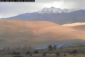
Updated notice on this long time down cam: The NPS is now saying that they have a new cam to replace the old cam, but they are having internet connection problems that are holding things up, as of Oct 1, 2021Since the NPS is taking a light year to get their new cam up, after so many years, many might not recall how its view looked. So, below is the old cam, that died, from one of the last days when it was still up online (hard to believe how long this popular cam has been down):
If the new cam is ever installed, it will show up here:

View from Great Sand Dunes Visitor Center showing:
1) Cleveland Peak, 13,414' 2) First ridge of Dunefield 3) Medano Creek bed ; 4)
Cottonwood Trees, Ponderosa Pines, and Pinyon Pines
(from Great
Sands Dune National Park, CO)
- Map -
| Colorado Web Cams | Alamosa | Hooper | Crestone | Crestone Weather Center |